Objective 2: infrastructure differences
For this objective, we compare Chicago’s north to Chicago’s south and west sides. Chicago is located in the Great Lakes region. In winter, frequent storm systems bring cloudy skies, windy conditions, and snow. In summer, high-pressure systems in the subtropical Atlantic draw warm and humid ocean air into the area, and mesoscale convective systems also lead to frequent rainfall and thunderstorms. Climate projections show a significant increase in annual precipitation, with uncertain summer precipitation-related changes. However, the frequency and intensity of heavy precipitation events are projected to increase, as Chicago is in a region most affected by climate change-induced heatwaves. Therefore, preparation for future extreme precipitation and extreme heat must recognize green development, including green infrastructure for stormwater management . Topographic differences between the north and south sides of Chicagoland also contribute to the intensity and behavior of flooding. To elaborate, the north side is situated in parallel morainal ridges with the Chicago, DesPlaines, and Fox Rivers and tributaries gathering water across increasingly impervious urban development; the southside is characterized by a high water table that is perched above clay soils such that urban development has occurred in areas previously occupied by lakes, bogs, marshes, and wetlands whose hydrographic profiles persist.
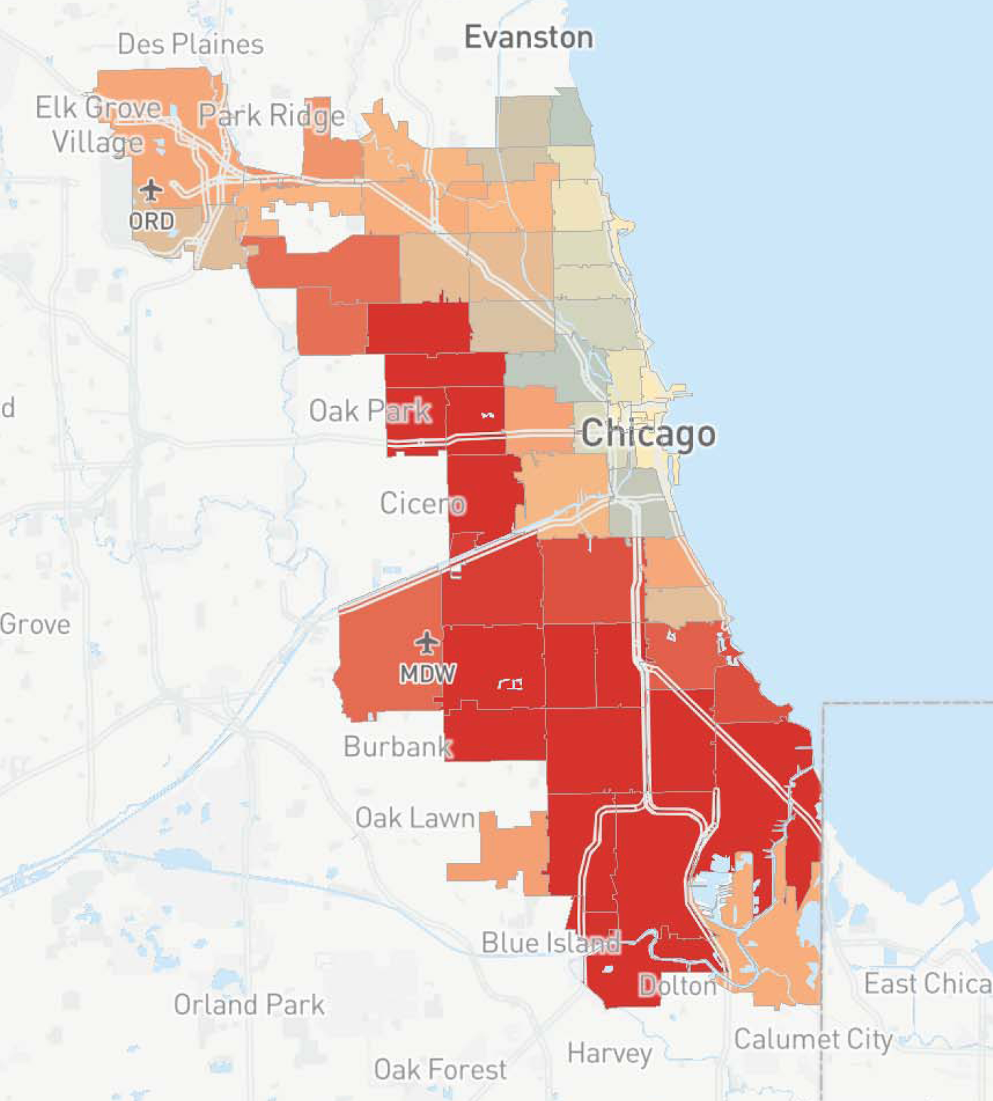
There is significant variance in flooding-related impacts between Chicago’s north and south sides. The figure above presents flooding-related insurance claims by zip code from 2007 to 2016, based on information provided by the Center for Neighborhood Technology, where light yellow represents 0-201 claims, gray represents 201-1,309 claims, peach represent 1,309-5,355 claims, and red represents more than 5,355 claims. As well, infrastructure investments typically flow to higher-income areas; therefore, we hypothesize that an analysis of the existing green infrastructure in cities will show similar trends. Previous research has provided a preliminary confirmation of these results. The effects of this inequity are manifested as increased flood inundation risks, in addition to disparities in recreational spaces and relief during heat waves. We will explore this issue through an in-depth analysis of the existing conditions in Chicago. This objective will be accomplished through the completion of three tasks: (1) analyze the existing flood inundation risks in low-income areas using hydrologic models (Task 2.2), (2) determine the geospatial relationship between green infrastructure and income levels (Task 2.3), and (3) quantify the relationship between flood inundation risks and income levels in the present climate (Task 2.4). But, first, we must develop an equity index at the community level to classify shortages in green infrastructure (Task 2.1)
Task 2.1: Develop an urban planning approach for equitably implementing green infrastructure. Traditionally, stormwater systems and retention basins have been utilized to reduce precipitation damage. However, with the recent recognition of the importance of resilience as part of sustainable development, mitigation strategies are shifting from direct development of prevention facilities to an urban planning prevention approach. Promoting green infrastructure as a stormwater management technique to mitigate the effects of climate change in a city necessitates the development of a more distributed urban environmental management system, through which the community stormwater department coordinates with a range of public and private stakeholders, which shifts power from the utility to other stakeholders. These distributed urban environmental management strategies can lead to more inclusive outcomes, but only if there is an intentionality about how funds are distributed, which communities are prioritized, how partners are chosen and cultivated, and which types of projects are implemented in which neighborhoods. We will develop an equity index to help identify communities that would most benefit from green infrastructure investment to ensure equitable green infrastructure planning, which will provide a much more nuanced analysis of communities that takes into account both supply and demand of green infrastructure for water regulating services, including social and economic conditions, the built environment, land ownership, and landscape patterns. This index will provide a visual tool that communities can use to understand underlying conditions and the existing placement of green infrastructure and serve as a framework that can be tailored to allow communities to weigh their priorities.
A GIS-based green infrastructure spatial planning model (GISP) will be developed using a spatial multi-criteria evaluation framework that incorporates stakeholder priorities, so the results serve as collaborative decision-support tools to visualize the implications of their preferences and identify tradeoffs in policy goals, as well as to build support for sustainable and resilient solutions. The criteria to evaluate the distribution of ecosystem services and identify priority areas include: (1) reduction in flood inundation risks, (2) reduction in social vulnerabilities, and (3) access to green space. The GISP model will incorporate stakeholder input to weight these criteria. Also, the model will introduce a helpful methodology and tool to examine spatial benefit tradeoffs and synergies of specific green infrastructure interventions designed to manage urban flooding. This GISP approach advances spatial multicriteria evaluation modeling for green infrastructure by integrating an array of ecosystem services and local stakeholder priorities and by assessing tradeoffs and synergies to facilitate equitable distribution and leverage co-benefits.
Task 2.2: Analyze existing flood inundation risks in low-income areas. Computing the inundated areas for a given recurrence period such as the 100-year flood (1% annual exceedance probability flood) requires hydrologic and hydraulic models. For this project, the U.S. Environmental Protection Agency (EPA) Stormwater Management Model (SWMM), which is a continuous rainfall-runoff model that predicts runoff volumes and water quality from urban watersheds, will be used to predict flow in networks in the target watersheds. Recent SWMM enhancements enable quantification of the impacts of various infrastructure components including low-impact development on runoff volumes and water quality. The model requires detailed information on the existing storm sewer and retention basin infrastructure, land use, and elevation maps, which will be obtained from the Chicago MWRD. The models can be used to analyze the effects of alternative stormwater management practices, such as constructing detention basins on marginalized lands, which could then prevent flooding in other areas. SWMM must be coupled with another tool that makes use of a high-resolution digital elevation model (DEM) to produce inundated area maps. We will use Itzï, which provides open-source extensions to SWMM, to visualize flood inundation. Cook County has developed LiDAR-based DEMs with a resolution of less than 2 m that will be combined with the SWMM model to produce maps of inundated areas based on the existing 24-hr duration, 100-yr return period storm. The Coordinated Hazard Assessment and Mapping Program at the Illinois State Water Survey has produced updated digital maps showing areas prone to flooding; we will make use of these existing maps as a check on model results, then proceed to use the model results along with existing geospatial data on socio-economic status as described in Task 2.1.
Task 2.3: Determine the geospatial relationships between socioeconomic and built environmental factors and green infrastructure. The unequal distribution of green infrastructure is the result of socioeconomic and built environmental factors. We will investigate the spatial distribution and quantify the benefits of green infrastructure within Chicago to determine how patterns of green infrastructure vary amongst communities in terms of socio-economic status and built environments. First, we will use the Green Infrastructure Baseline Inventory database collected by the Metropolitan Planning Council (MPC) to identify the areas regarding the regional stormwater interventions. The existence of the MPC green stormwater infrastructure database will provide unique opportunities to assess alternative strategies to identify and utilize alternative approaches in locations where such data are not present. Land-use databases and satellite remote sensing data are commonly used to collect green infrastructure data in urban areas. We will collect additional green infrastructure data from the National Land Cover Database, Meter Scale Urban Land Cover, NeighborSpace, and the Chicago Park District. Types of green infrastructure include public green space represented by park area and tree canopy cover and private green space represented by residential area and tree canopy cover. Second, in order to measure the variation of socioeconomic status and built environments, we will use the Social Vulnerability Index (SoVI) accessed via NOAA created by the Hazards and Vulnerability Research Institute. Arguably as the most well-established and widely used methodology, SoVI is a composite index of socioeconomic and demographic variables that research has shown relate to susceptibility to natural hazards, but 11 of the variables (including wealth, age, density of the built environment, housing, and race) account for more than 75 percent of variance between U.S. counties. The SoVI provides census tract scores for the 29 variable index across our study areas. Third, spatial statistics will be used to identify the clusters and outliers of green infrastructure. Regression models will be used to examine the relationships between green infrastructure and socioeconomic and built environmental factors. We will also attempt to develop algorithms for predicting the presence of green infrastructure in other locations using the information in the MPC database.
Task 2.4: Quantify the relationship between flood inundation risks and income levels in the present climate. The modeling tools that are developed in Task 2.2 will be used to assess the current status of flood risks within the target regions, and the GIS tools developed in Task 2.1 will provide a mechanism to assess green infrastructure. The combination of the two will be used to analyze the current status of green spaces and how they relate to potential flood risks. As part of this task, we will present a new tool that utilizes remote sensing and census data to model the supply for urban flood reduction services through green infrastructure. A high-resolution urban digital model will be used to distinguish between permeable and impermeable areas at fine (e.g., 25-cm) spatial scale. We will model flood reduction capacity using two indices: (1) the amount of runoff reduced by existing green infrastructure, and (2) the runoff reduction coefficient. The tool will be demonstrated with different scenarios to show the distribution of flood reduction capacity in terms of ownership and landscape patterns and thus identify priority areas of intervention, based on the mismatch between supply and demand of green infrastructure for water regulating services. We will coordinate this task with MWRD and the stakeholders from the CSC to provide improved understanding of the present levels of flood inundation inequities around the city to raise awareness and improve infrastructure adaptation.